
Together we are making a difference one mile, one registration, one sponsorship and one volunteer at a time. The pictures below show you part of the first house we helped furnish for Oasis House in 2014. Help us maintain the house and reach our goal of $10,000 in 2015 by giving online at http://www.imathlete.com/donate/MilesforFreedomOasisHouse


October 3rd Logistics for MFF event @MidwestOutdoorExperience
MIDWEST OUTDOOR EXPERIENCE (MOX) will open Friday night 6-10 pm and will re-open Saturday morning at 11:00 am. Stay around after MFF and enjoy live music, over 200 exhibitors, dog shows, BMX/Skateboard stunts, food trucks and more. Admission and parking are FREE!
ON THE MAP BELOW YOU WILL FIND THE START OF MILES FOR FREEDOM AT THE “INLINE SKATING” AREA.
-
Address- Eastwood MetroPark
-
1385 Harshman Road Dayton, Ohio
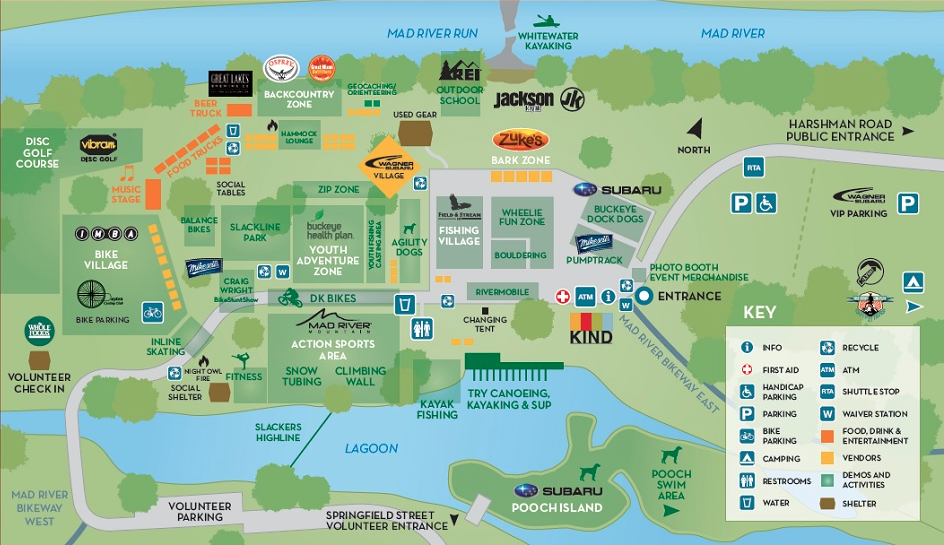

- Check-In at Start/Booth 1- NEXT TO RESTROOMS and BRIDGES that cross creek- See MAP ABOVE.
- PLEASE REGISTER ONLINE BEFORE YOU ARRIVE IF POSSIBLE TO HELP WITH START TIME.
2. Ride Details (Hydration/Food Stations see #5) (If possible wear event shirt day of group ride so people on the trail will no what you are doing!)
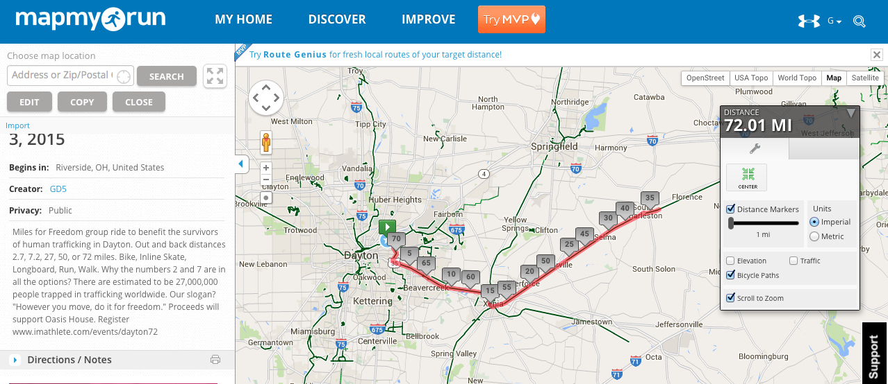
- The complete 72 MILE distance takes place by going from Eastwood MetroPark to South Charleston Station and back to Eastwood MetroPark.
-

Where will you turn around for freedom? Tag #milesforfreedom with your selfie at your sign!! - The Mileage Signs above will be placed at the 2.7, 7.2, 27, 50 and 72 miles “Turn Around” the morning of the event; however, signs were knocked over at our last event and some people missed them so be prepared to track your mileage as back up.
- The trail also has permanent mileage markers on most of the trail pavement and at some of the crossroads or parking areas.
- THE START will be at the “Springfield Rd” entrance (Parking only for MOX volunteers) of Eastwood Metropark and connect to Creekside Trail #2
- Around 2 miles you will make a 90 degree left turn to stay on Creekside Trail #2 I35 will be parallel to you on your right
- Stay on Creekside Trail #2 heading east towards snack booths and restrooms at Beavercreek Station(Mile 8), and Xenia Station (mile 16.3)
- Xenia Station (150 S. Miami St Xenia, OH 45385) is the end of Creekside Trail #2. Volunteers will direct you to the Ohio to Eerie Trail #1 that goes towards Cedarville (Mile 24.3) and South Charleston Station restrooms (Mile 36)
- #1 Trail is located by crossing the CROSSWALK at Intersection of South Detroit St and South Miami Ave. Go left on sidewalk next to South Detroit St and you will see trail on right off side street of Hill St. (Intersection of S. Detroit and Hill St)
- THIS IS NOT A RACE. Please be considerate of the non-participants and the STOP SIGNS AT ROADS!

3. Safety Details
- WEAR HELMETS, and protective gear
- Bring proper water, food, and nutrition for the distance you will be traveling (Drink water before coming)
- Tools, parts and replacement wheels for inlines, inner tubes for bikes etc (Be self sufficient, Be prepared)
- For an emergency in any county, please dial 911
Remember to describe your approximate location on the Bike Trail by:- Watching and knowing the closest mile marker
- The name of the last trailhead or street you passed
- The name of the trailhead where you entered/parked
- If you traveled east or west
- Approximately how far you’ve traveled
Note: Cell phone coverage is spotty or nonexistent in places, so tracking your location by cell phone may not be reliable.
- ALWAYS PASS ON THE LEFT AND ANNOUNCE THAT YOU ARE “PASSING ON LEFT”
- Please do not RACE! This is a group ride for awareness and there will be many non-participants on the trail that are not expecting us.
4. NO OVERNIGHT PARKING (you will be towed)
5. HYDRATION AND/OR NUTRITION STATIONS at MILE NUMBER’S- 1.35, 3.6, 8, 12.3, 16.3, 24.3, 36
- 1.35 mile marker “TURN AROUND” sign for 2.7 Mile events (Water only)
- 3.6 mile marker “TURN AROUND” sign for 7.2 Mile events. This mile marker will come just after you make the LEFT TURN TO STAY ON #2 TRAIL that parallels I35. It is a slight hill to the turn around, but fast on way back. (Water only)
- Mile 8- Beavercreek Station – 1153 N Fairfield Rd, Dayton, OH 45432 (restrooms, bottled water and fruit available. If the weather is nice the parking lot will fill up fast!)
- Mile 12.3- William Maxwell Rest Area- Picnic Tables in shaded park just short of Kil-Kare Speedway. (Bottled water and hopefully fruit)
- Mile 13.5- There will be a “Turn Around” sign for the 27 mile events just past the Kil-Kare Speedway Dragstrip after you cross over HAWKINS RD- NO VOLUNTEERS or WATER-
- Xenia Station booth- Mile 16.3- 150 S. Miami St Xenia, OH 45385 (Bottled water and snacks, Restrooms in the old train station, pull the door on the far right IT’S NOT LOCKED JUST PULL IT. Many people don’t realize that)
- Cedarville- Mile 24.3 – The Community Park is near 13 East St, Cedarville, OH 45314 Trail crosses N. Main Street and the park is on the left (restrooms, drinks, and snacks) Cedarville also has a few restaurants nearby.
- South Charleston – Mile 36- Go all the way into the park next to the old Train Station for restrooms and the turn around spot! Peanut Butter and Jelly Sandwiches, bananas, drinks, and snacks)
- Notice the booths are spread out and will not be sufficient for water
- OTHER REST AREAS ARE AVAILABLE CHECK CREEKSIDE #2 MAP HERE and Ohio to Eerie Trail #1 Here
- PAUSE AT MILE 27 TO REMEMBER THE 27 MILLION
6. Please email and tag pictures or videos #milesforfreedom that you take of the event so that we can put a follow-up video together!
THANK YOU EVERYONE FOR YOU PARTICIPATION IN FUNDRAISING AND SPREADING AWARENESS!
